LiDAR
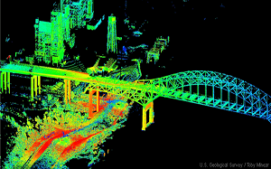
RemotLight Detection and Ranging or LiDAR, is the technology that utilises lasers to determine the distance to an object or surface. LiDAR mapping can be either airborne or terrestrial. In airborne LiDAR, a pulsed laser ranging system is mounted on an aircraft which is equipped with a precise kinematic GPS receiver and an inertial navigation system (INS).